GEOTECHNICAL ENGINEERING1
SWINDON
HomeGeophysicsElectrical resistivity / VES (Vertical Electrical Sounding)

Electrical Resistivity Testing (VES) in Swindon: Subsurface Profiling for Infrastructure Projects

Practical geotechnics, field-tested.

LEARN MORE

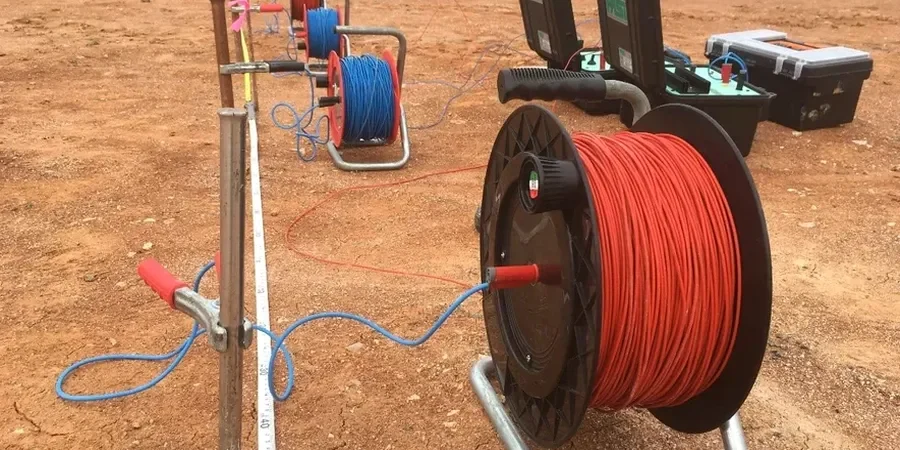
We ran a resistivity line last autumn across a proposed warehouse site near the A420. The client needed to know bedrock depth before piling design. Swindon's geology isn't uniform. The southern edge sits on coral-rich limestone of the White Horse country, while the north transitions into Oxford Clay. That contrast creates a perfect scenario for electrical methods. We set up a Schlumberger array with a maximum AB/2 of 150 metres. The data showed a clear resistive layer at 8 metres depth. Correlating that with a single CPT test confirmed it was the Cornbrash formation. The survey took four hours. The report was delivered the next day. No drilling damage, no traffic disruption, no guesswork. That's the power of a well-executed VES survey.

A VES survey in Swindon's Oxford Clay can map the weathered-to-competent transition without a single borehole. That saves weeks in the site investigation programme.
Our service areas

Process and scope

Swindon's expansion from a railway town to a logistics hub put immense pressure on its underlying geology. The historic Great Western Railway works were built on alluvial gravels. Modern distribution centres now spread onto the Kimmeridge Clay outcrops west of the M4. These clays are conductive. Resistivity values below 20 ohm-m are common. The limestone bands, in contrast, exceed 100 ohm-m. This electrical contrast makes Vertical Electrical Sounding the most cost-effective reconnaissance tool here. We use four-electrode arrays with automated switching units. Current injection cycles are short. Data stacking reduces noise from nearby power lines. Each sounding curve is inverted with least-squares algorithms.
We then calibrate the geoelectric layers against existing borehole logs from the British Geological Survey database. The result is a 1D model of true resistivity versus depth. From that we interpret lithology boundaries, water table position, and clay thickness. All processing follows BS 5930:2015+A1:2020 guidelines for geophysical investigation.
Electrical Resistivity Testing (VES) in Swindon: Subsurface Profiling for Infrastructure Projects
Technical reference — Swindon

Local considerations

The Gault Clay formation under eastern Swindon presents a specific hazard. It's a thin band between the Upper Greensand and the Lower Chalk. Resistivity values sit in a narrow range of 15 to 30 ohm-m. Misinterpreting this layer as Oxford Clay leads to incorrect pile socket depths. We've seen it happen. A contractor assumed 25 metres of clay based on a single borehole. A VES survey three months later revealed the Gault was only 4 metres thick. The chalk was at 12 metres. Socket redesign saved the project from a six-figure overrun. Another risk is buried utilities. Old railway sidings left metallic debris across multiple sites. Induced polarisation effects can distort the apparent resistivity curve. We always check historic maps before survey design. Signal contamination from the overhead catenary along the mainline also requires careful filtering during processing.

Need a geotechnical assessment?

Reply within 24h.

Email: contact@geotechnical-engineering1.com

Reference standards

BS 5930:2015+A1:2020 – Code of practice for ground investigations, BS EN 1997-2:2007 – Eurocode 7: Geotechnical design – Ground investigation and testing, BS 1377-3:2018 – Methods of test for soils for civil engineering purposes – Chemical and electro-chemical testing

Reference parameters

ParameterTypical value
Array configurationSchlumberger (standard), Wenner (optional)
Maximum investigation depthAB/2 up to 200 m
Typical depth range in Swindon clays30 to 80 m
Current injectionUp to 500 mA DC, auto-reversing
Data acquisition systemMulti-electrode with 24-bit ADC
Inversion algorithmSmoothness-constrained least-squares
Compliance standardBS 5930:2015+A1:2020

Questions and answers

What depth can a VES survey reach in the Swindon area?

Depth penetration depends on the array aperture and the subsurface resistivity. In the conductive Oxford Clay, we typically achieve 50 to 80 metres with an AB/2 of 200 metres. In the more resistive Corallian limestone south of Swindon, the same array can reach beyond 100 metres. The limiting factor is signal-to-noise ratio, not equipment capability.

How much does an electrical resistivity survey cost in Swindon?

A single VES sounding in the Swindon area ranges from £460 to £890, depending on the maximum depth required and site access conditions. A 2D ERT profile typically falls between £1,200 and £2,400 per line. We provide fixed-price quotations after reviewing the site location and project objectives.

Is the method affected by the railway infrastructure in Swindon?

Yes, it can be. The overhead catenary lines along the Great Western Main Line generate 50 Hz electromagnetic noise. Our acquisition system includes notch filters and stacking routines to suppress this interference. We also orient survey lines perpendicular to the tracks where possible and use shorter current injection cycles. Historic maps help us avoid buried metallic debris from the old railway works.

How do you calibrate resistivity data to actual soil types?

The reference range for this service in Swindon is £460 - £890. The final price depends on the project scope and volume.

What is the difference between VES and ERT?

VES is a 1D method. It measures resistivity variation with depth at a single point. ERT is a 2D method. It produces a cross-section of resistivity along a line. We use VES for quick depth-to-bedrock reconnaissance or groundwater exploration. We use ERT when lateral changes matter, like mapping clay-lens boundaries or locating abandoned mine shafts in the limestone. Both methods use the same physical principle and equipment.

Location and service area

We serve projects in Swindon and surrounding areas.

View larger map